Skip to the content
Free-map.orgFree-map.orgFree-map.org
News from the world of maps
  • News
  • World Map
  • Satellite Map
  • Street View
  • Blog
  • Facebook
  • Contact
  • Home
  • Blog
  • The real size of the 8 largest countries on Earth
The real size of the 8 largest countries on Earth
Blog

The real size of the 8 largest countries on Earth

Avatar for Free-map.org
Free-map.org
November 10, 2022November 10, 2022

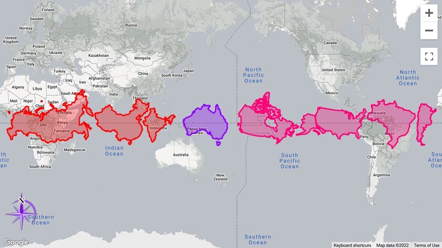
Russia, China, India, Canada, USA, Australia, Brazil, Argentina … How big these countries really are? This map will tell the truth

The popular Mercator projection distorts the relative size of landmasses, exaggerating the size of land near the poles as compared to areas near the equator. If we move countries near the equator, we see their real size.
Leave a Reply Cancel reply

You must be logged in to post a comment.

Previous post Artillery and air strikes in Ukraine
Ukrainians granted temporary protection in September Next post Ukrainians granted temporary protection in September

Related Post

Blog Maps

The first image of Earth from space

Avatar for Free-map.org
Free-map.org
November 13, 2025November 13, 2025
Blog Maps

London on the Map: A Global City’s Geographic Significance

Avatar for Free-map.org
Free-map.org
April 17, 2025April 18, 2025
Blog Maps

Amazing satellite views of city layouts

Avatar for Free-map.org
Free-map.org
March 13, 2025March 13, 2025
Blog Maps

Round Gardens in Denmark

Avatar for Free-map.org
Free-map.org
February 18, 2025March 4, 2025
Blog

Which countries can go to USA without visa?

Avatar for Free-map.org
Free-map.org
July 13, 2023
Blog

Life expectancy at birth down to 80.1 years in 2021

Avatar for Free-map.org
Free-map.org
March 22, 2023March 22, 2023

Post navigation

Previous post:

Artillery and air strikes in Ukraine

Next post:

Ukrainians granted temporary protection in September

Recent Post

Pac-Man Returns to Real Streets: New Browser Game Lets You Play on Any Neighborhood Map

Borderline: The Game That Tests How Well You Really Know the World’s Borders

Tourists Popular Regions in early 2026 in EU

Interactive Map Reveals Scale of U.S. Third-Country Deportations Under Trump Administration

Music Map The World Today launches interactive global view of daily music charts on Rotation

Top Category

News

Blog

Street View

  • News
  • World Map
  • Satellite Map
  • Street View
  • Blog
  • Facebook
  • Contact

Satellite view map

Country Maps: Albania | Argentina | Austria | Australia | Bangladesh | Belarus | Belgium | Belize | Bolivia | Brazil | Bulgaria | Canada | Chile | China | Colombia | Congo | Costa Rica | Croatia | Czech Republic | Denmark | Ecuador | Egypt | El Salvador | England | Ethiopia | Finland | France | Germany | Greece | Guatemala | Guyana | Honduras | Hungary | India | Indonesia | Iran | Ireland | Island | Italy | Japan | Latvia | Lithuania | Mexico | Moldova | Netherlands | Nicaragua | Nigeria | North Macedonia | Norway | Pakistan | Panama | Paraguay | Peru | Philippines | Poland | Portugal | Romania | Russia | South Korea | Slovakia | Slovenia | Spain | Thailand | Suriname | Sweden | Switzerland | Turkey | Ukraine | United States | Uruguay | Venezuela | Vietnam

City Maps: Beijing | Berlin | Brussels | Buenos Aires | Chicago | Cairo | Delhi | Dhaka | Houston | Istanbul | Karachi | Lagos | London | Los Angeles | Madrid | Mexico City | Moscow | Mumbai | New York | Paris | Osaka | Rome | Sao Paulo | Shanghai | Sydney | Tokyo | Warsaw

Top Street View: London | Los Angeles | Madrid | Miami | New York | Paris | Sydney |

Copyright © 2026 Free-map.org. All rights reserved.
Theme: Masonry Grid By Themeinwp. Powered by WordPress.
To the Top ↑ Up ↑

Privacy Policy