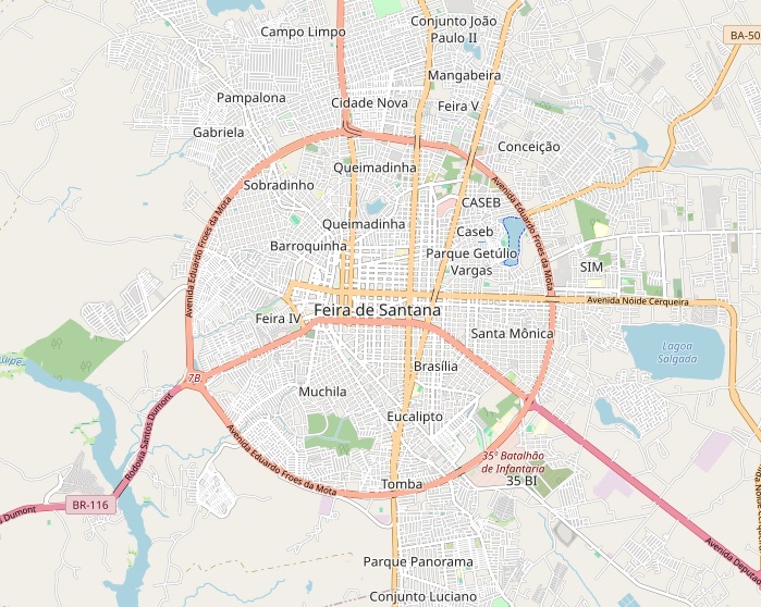

In Feira de Santana, the second-most populous city in Bahia and a major road junction in Brazil’s North-Northeast, the Avenida do Contorno (also known as Anel de Contorno or Avenida Eduardo Fróes da Mota) forms a striking near-perfect circle around the historic urban core. Map and Satellite View.
The roughly 24-kilometer ring road, planned in the 1950s–60s and completed as a full circumference in the 1980s, was designed to divert through-traffic from the city center while linking key federal and state highways including the BR-324, BR-116, BA-502 and BA-503.
A map of the city clearly highlights the ring’s almost perfectly circular geometry, which divides Feira de Santana into intra-anel (inside the ring) and extra-anel (outside the ring) zones. An aerial view reveals how the avenue neatly encircles the denser central neighborhoods, with radial avenues radiating outward from the core to meet the contorno. From a satellite view, the road’s smooth, closed loop appears especially striking against the surrounding urban expansion and landscape, underscoring its role as both a practical traffic corridor and a visual landmark.
Local accounts and historical notes describe the Anel de Contorno as a deliberate planning choice to manage growing freight and passenger flows as Feira de Santana consolidated its position as a regional logistics hub. Over time the city has expanded well beyond the original ring, yet the avenue remains a key reference point for mobility, commerce and urban identity. Ongoing duplication and improvement works on sections of the ring aim to ease congestion while preserving its distinctive circular form.
Whether examined on a map, captured in an aerial view or observed from a satellite view, the near-perfect circle of Feira de Santana’s ring road continues to draw attention as one of the more geometrically distinctive urban features in the Brazilian Northeast.